
Wildfires can become so intense that they produce thunderstorms. This phenomenon of fire-triggered thunderstorms is called pyroCbs, which is short for pyrocumulonimbus clouds.
Pyrocumulonimbus clouds are also known as cumulonimbus flammagenitus. Cumulonimbus flammagenitus stems from the Latin words meaning “flame” and “created from.” NASA researchers refers to pyroCbs as the “fire-breathing dragon of clouds“.
While the exact physics behind these fire-triggered thunderstorms is still being researched, pyroCbs are triggered by the uplift of ash, smoke, and burning materials via super-heated updrafts. Wildfire flames release enough heat and moisture into the atmosphere to produce thunderstorms. As these materials cool, clouds are formed that behave like traditional thunderstorms but without the accompanying precipitation.
These pyroCbs produce dry lightening which can trigger further wildfires.

The difference between PyroCu (Pyrocumulus) and PyroCb (Pyrocumulonimbus) clouds
The terms “PyroCu” and “PyroCb” refer to different types of clouds associated with wildfires or intense heat sources, typically from forest fires, volcanic activity, or industrial fires. The main differences between these two types of fire-driven clouds is based on their formation and structure:
PyroCu (Pyrocumulus)
A pyrocumulus cloud is a type of cumulus cloud that forms over intense heat sources like wildfires or volcanic eruptions. The intense heat causes strong updrafts, lifting hot air and moisture high into the atmosphere, where the moisture condenses to form clouds. These clouds can resemble regular cumulus clouds but are triggered by heat from the ground rather than by regular convection.
- Appearance: Looks like a regular cumulus cloud but forms due to a heat source.
- Formation: Occurs when hot air rises rapidly, lifting moisture from burning vegetation or other sources into the atmosphere.
- Weather Impact: PyroCu clouds may lead to localized thunderstorms if they grow large enough, potentially intensifying wildfires by creating lightning.

PyroCb (Pyrocumulonimbus)
A pyrocumulonimbus (PyroCb) cloud is a much larger, more intense version of a PyroCu. It is essentially a thunderstorm cloud (cumulonimbus) that forms over a wildfire or other heat source. As the updraft continues to build, the PyroCu may develop into a PyroCb if the heat and moisture are strong enough.
- Appearance: A towering, dense, and dark cumulonimbus cloud with an anvil shape at the top, typical of thunderstorms.
- Formation: Starts as a pyrocumulus cloud that continues to grow due to the sustained heat and rising moisture from the fire. The cloud reaches the upper atmosphere and can produce lightning, strong winds, and even rain.
- Weather Impact: PyroCb clouds can create dangerous conditions, as they generate thunderstorms and lightning, which can spark new wildfires. They can also produce strong downdrafts that fan existing flames.

Key differences between pyroCb and pyroCu clouds
- Size and Intensity: PyroCb clouds are larger and more intense than PyroCu clouds.
- Weather Activity: PyroCu clouds may be relatively benign but can develop into PyroCb clouds, which are associated with severe thunderstorms and lightning.
- Formation Stage: PyroCb represents the later, more developed stage of a cloud formation over intense heat sources, while PyroCu is an earlier, less developed form.
In summary, a PyroCu is an initial cloud formation from a heat source, while a PyroCb is a fully developed thunderstorm cloud that can result in severe weather events.
How climate change is fueling pyroCbs
Scientists are studying how climate change, which is driving larger and more intense wildfires, are also creating a higher frequency of pyroCbs.
Fire-triggered thunderstorms are being generated in places that have never experienced this phenomenon before such as Texas, Portugal, South Africa, and Argentina (Related: Smoke from Australian Wildfires Reaches Atmospheric Highs). pyroCbs are particularly destructive due to the tornado-strength vortexes that are produced.
A single pyroCb can send particles as high as 10 miles into the lower stratosphere according to Dr. Glenn K. Yue, an atmospheric scientist at NASA Langley Research Center in Hampton, Virginia.

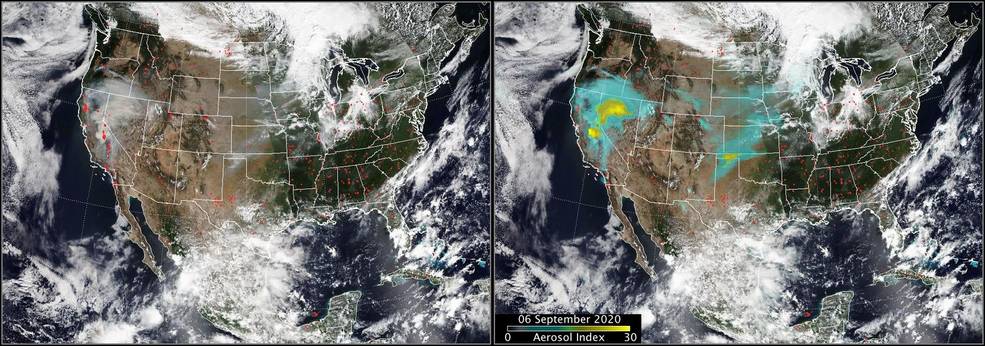
One of the Largest pyroCb Events Seen in the United States
On September 6, 2020, NASA’s Suomi NPP satellite was able to measure the “largest (if not the largest) pyroCb events seen in the United States,” according to Dr. Colin Seftor, Atmospheric Scientist at Goddard Space Flight Center in Greenbelt, Maryland.

The pyroCb cloud was triggered by the the Creek Fire which began in the Big Creek drainage area between Shaver Lake, Big Creek, and Huntington Lake in California. Sensors onboard the Suomi NPP satellite measured aerosol index values indicating this was one of the largest pyroCb events ever recorded.
References
Reed, J. (2020, October 16). California’s Creek fire blasts smoke into the stratosphere. NASA Applied Science.
Struzik, E. (2019, January 24). Fire-induced storms: A new danger from the rise in wildfires. Yale E360.
This article was originally written on October 29, 2020 and has since been updated.